In search of the annual slipper's exhibition at Tripaille-en-Paumé, known rather locally, you realize with astonishment a mistake on your trip. Instead of taking the motorway A234 exit towards the industrial area of Letron la Trine, you have turned too early by taking the path of the friend's club of camembert boxes carving at the roundabout of Bermudaille-en-Paté… Waaah the mess! Unable to locate on the map! But there is maybe a way to find at least our latitude… Otherwise you can also turn on the gps or ask your direction to be more effective!
1) The sun, a stick, something to measure…And the right time
We often think that round earth discovery as a soccer ball is attributed to Christopher Columbus only, in fact reality is more complex. He has proved this empirically with his travels, but he has demonstrated a theory already thought for a long time. Several centuries earlier(5century before JC)Platon saw already earth as a sphere. In fact, Greeks had already noticed the curved nature of the Earth's surface(a vessel which is heading on horizon sees its hull disappears first, then the mast foot, and finally the rest). But in the 2nd century before JC a Greek managed through a very simple method to calculate the circumference of our soccer ball, with an incredible precision for his time(700 km only of difference with our current value!)it's Eratosthène.
His reasoning was as follows: as the earth is curved, sunbeams then reach the earth's surface at different angles. He added to it some trigonometry to season and that's all.
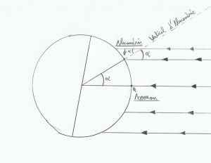
For its calculations he considered Sun's rays parallel between them(because this star relative to Earth is much larger and very far). At the time he knew that when it was 21 June(summer solstice), at local noon in Aswan vertical silhouettes drew no shadow, He therefore concluded that at that time the Sun was located on the line perpendicular to the tangent through Aswan. After all that it is easy to guess the angular distance between Aswan and Alexandria(angla alpha Scheme), by planting a stick at Alexandria and observing its shadow at local noon the 21 June, we find alpha angle.
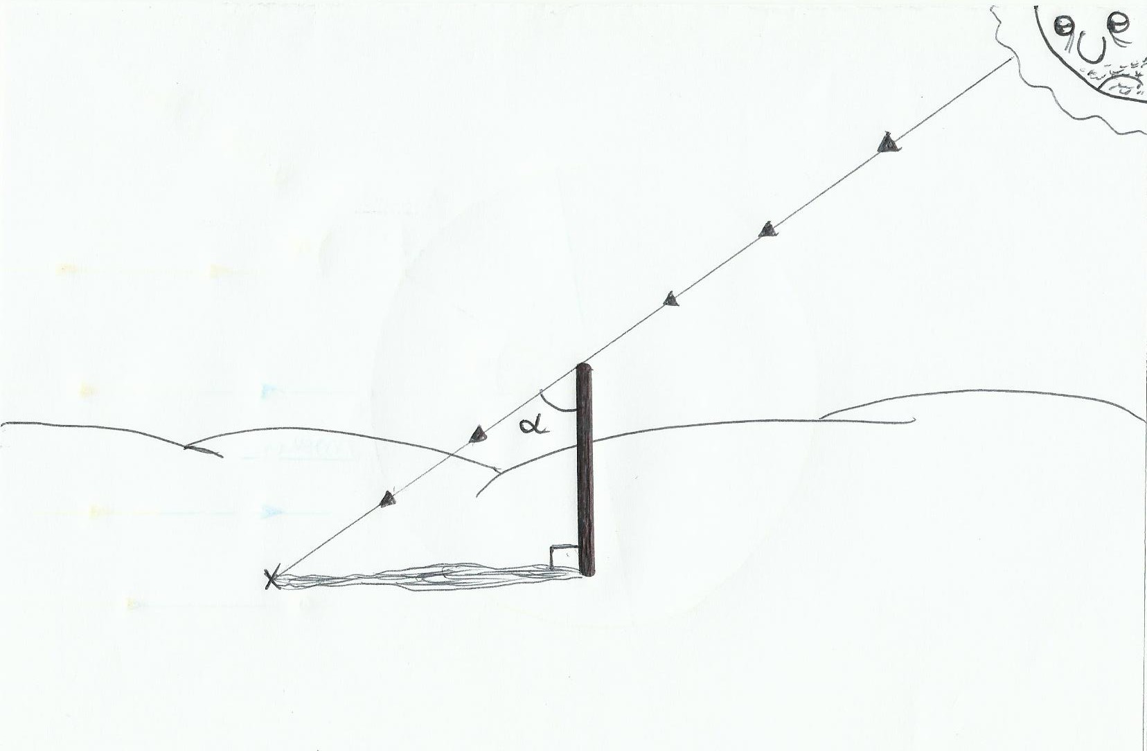
We must plant the stick as straight as possible(Use a plumb line)to have the most accurate possible measurement(to be more accurate, use as much as possible a long and thin stick, and a good plane ground ). By knowing the size of our stick and measuring its shadow we will be able quickly to find alpha angle with some trigonometry(the ensemble has a rectangular triangle shape). Why ? because Tan(alpha)= Opposite side / adjacent side so Tan(alpha)= Shadow length / stick length. Eratosthenes has found an alpha angle of 7, 2° roughly.
As he knew the distance between the two cities, and that 7, 2° is equal to 1/50 of 360°( the total circumference of the Earth)He then multiplied the distance between the two cities by 50 which gave 39350 km( the actual value is about 40033 km).
So you will say it's very nice all that stuff but to go to Tripaille-en-Paumé we are not more informed ! Yes sure, but by taking the problem in an another way we may find our latitude, roughly anyway…
Knowing the rule of the four 21(see Article “the celestial sphere”)about the foot's position of the sun during solstices(+or- 23 ° 26′) and equinoxes(0°)in latitude. So if in this case we want to know the latitude of Alexandria we simply add the alpha angle at Aswan latitude. Aswan has a latitude of about 24 °(logical because at summer's solstice, the 21 June the foot of the sun has a latitude of 23 ° 26′, and at that date there is no shadow for vertical silhouettes in Aswan)So Alexandria latitude is 31 ° roughly.
Now in our case if we are lost the 22 September and we calculate alpha angle at local noon(to find local noon with our stick, this is when it will draw on the ground the shortest shadow in the day, because at that time the sun will be highest on the horizon), if alpha is equal to 51 ° this means that our latitude is 51 °(For the day of the autumnal equinox foot latitude of the Sun = 0 ° at local noon roughly). After that to know Sun's foot latitude all the year we must have ephemeris into our glove compartment…
Notice: if we can define with accuracy local noon hour of our position(through stick's shadow which shrinks until local noon then grows after), and if our watch is adjusted on UT time precisely, and if by miracle we have in hands ephemeris then we will be able to find our longitude too.
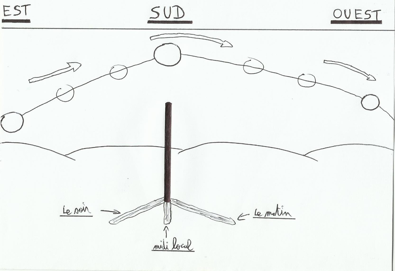
To find our local noon hour precisely, we will do almost the same method used for "the meridian"(see Article “The Meridian”). As the sun is at its zenith for a while, hard to find the exact local noon hour just by measuring the size of the shadow when it appears to be smaller. In fact we will take a measure of the shadow when the sun is facing south-east (by noting the time at that time) with a tensed wire from stick's foot, and we draw at the ground an arc of a circle(with a radius equal to this measurement). When the shadow will cross our draw(the sun will be closer to the west) we immediately note the time; local noon hour is then the sum of these two hours divided by two.
In the ephemeris, we find time of sun's passage at Greenwich meridian(Greenwich local noon). So if our watch is in precise time UT, that we have managed to define our local noon then we will find our longitude. The sun revolves around the Earth(in our course repository!)at a rate of 15 ° per hour(this speed is anyway indicated more precisely in the ephemeris), so our longitude =(local noon hour-Greenwich local noon hour)*15.
2) Professor Tournesol's pendulum
In the article “Coriolis”, we have seen that the more we approach the poles the more Coriolis will deflect motion things on long distances(wind and current)to the right in the northern hemisphere and left in the southern hemisphere. Conversely the more you approach the equator and the more that “force” will decrease. So parked on the church's car park between Brignolle-la-Farfouillette and Létron-la-Trine, it is reasonable to ask whether there is not a link or formula between Coriolis and the change of latitude…When we get bored to death we must deal with something!
We may actually find a link through the Foucault pendulum, its principle works like a gyroscope. Basically when a pendulum oscillates(Considering the frictional forces null, the oscillating motion continues indefinitely), its oscillation's plane will remain fixed relative to earth rotation on itself, in fact it's the plan under pendulum which will turn relative to it. It is easy to deduce the rotation's speed of the pendulum's plane wether it's located on a pole:
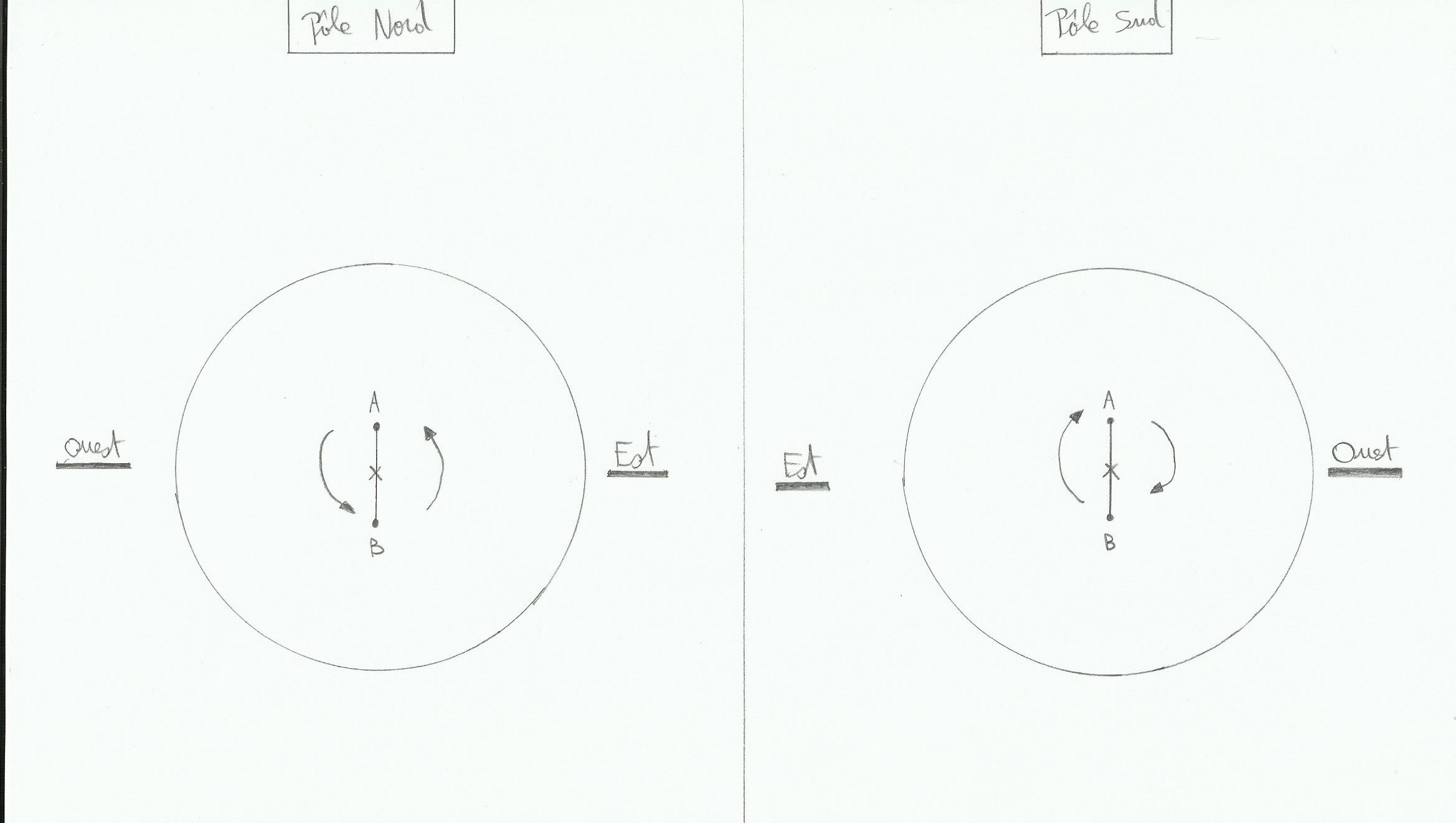
We'll say that the pendulum swings between A and B. If the pendulum is located right on the north pole then the plane under pendulum will turn at the rate of 15°per hour roughly in anti-clockwise sense(because the earth rotates on itself 24 hours so 360°per 24 hours, and the sun falls in the West). On the south pole it will be the same rate but in clockwise sense, and at the equator as Coriolis is null the plane will be motionless relative to the oscillating plane of the pendulum a. But then at Brignolle la Farfouillette, how it goes? In fact it creates an apparent motion of the pendulum in the opposite sense(North Pole, the pendulum rotates clockwise and at south pole counterclockwise).
And then the speed will depend on the latitude of the pendulum, due to the difference of linear velocity according to latitude. On the following diagram points B, A and C are located at different latitudes, their angular earth velocity is the same (360° in 24 hours), but not their linear velocity(because earth circumference decreases when the latitude increases, so the point will have less way to follow in 24 hours, so its linear speed will be slower if its latitude increases. In this diagram the center of the pendulum is A and it's oscillating between B and C; A's latitude is alpha angle and R is earth's radius:
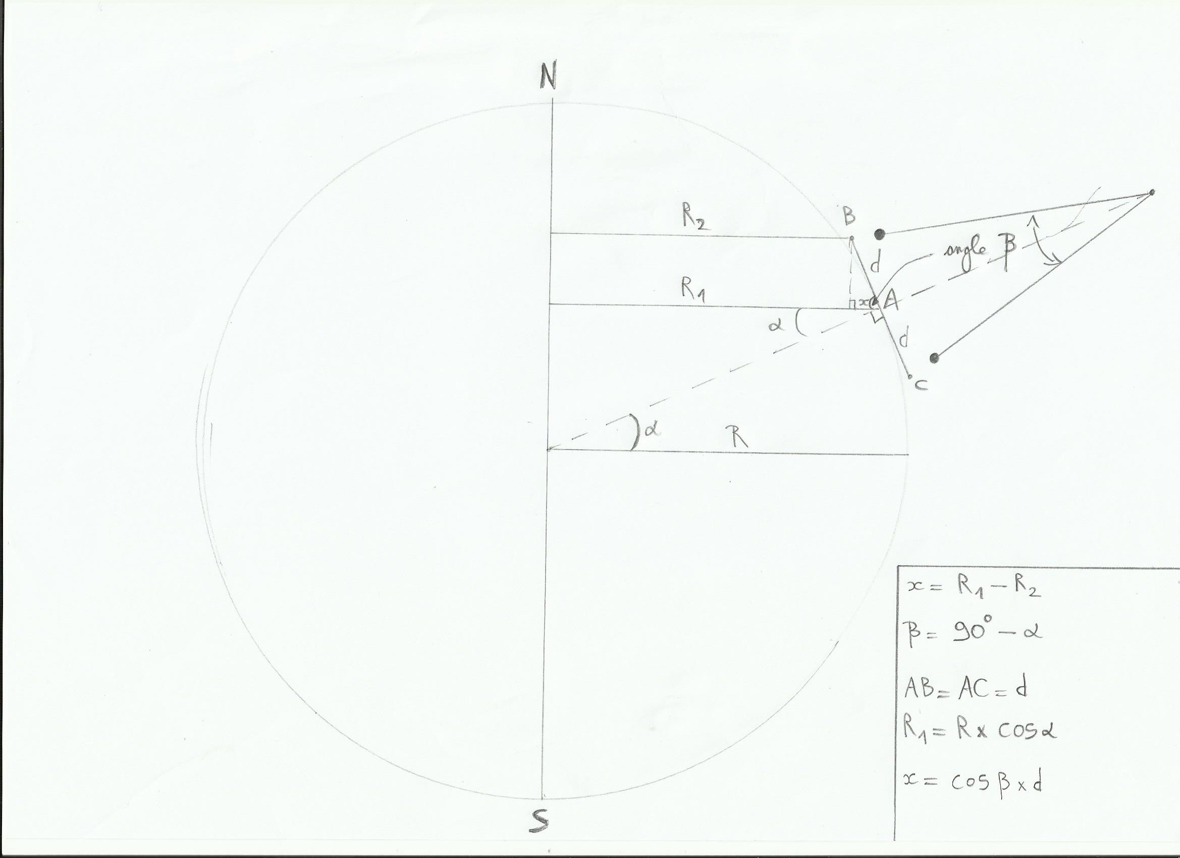
The linear speed of A is equal to the angular velocity of the earth(w) multiplied by R1 so Va = w *R1; R1=cos(alpha)*R. Then Va=w*cos(alpha)*R.
Vb=w*R2, and R2=R1-x. x=cos(beta)*d with trigonometry, or angle bêta=90°-alpha so cos(90°-alpha)= sin(alpha). x=sin(alpha)*d. Donc R2=cos(alpha)*R-sin(alpha)*d, Vb=w*(cos(alpha)*R-sin(alpha)*d)
With a similar reasoning we find Vc=w*(cos(alpha)*R sin(alpha)*d)
Finally we see that Vc>Va>Vb, and between each of these speeds the difference is w * sin(alpha)*d. This difference between the speeds will create the apparent motion of the plane under the pendulum. We can deduce that the angular velocity of this plan is w * sin(alpha), or the angular velocity of earth multiplied by latitude's sinus(we remove d which is plane's width, Independent of the angular velocity). To conclude we can write this equation:
rotation angle per hour = 15 * sin(latitude)
(Notice: On the poles with latitudes of 90 ° we find this principle above, just as with a latitude of 0 ° at the equator.)
3) Recall
Polaris height relatives to horizon give our latitude too(article “our position without GPS or calculator”). After that I have not tried it yet but knowing that Mintaka(Orion) is located almost on the celestial equator, maybe its height above the horizon without 90 ° gives our latitude…maybe. Alternatively to find our way we may ask our position to the first pedestrian met, it will be faster!